Relief and climate explain why the Russian river network assumes such a marked individuality, that it cannot be said to be found anywhere else on Earth, except for, and only up to a certain extent, the boreal belt of North America.
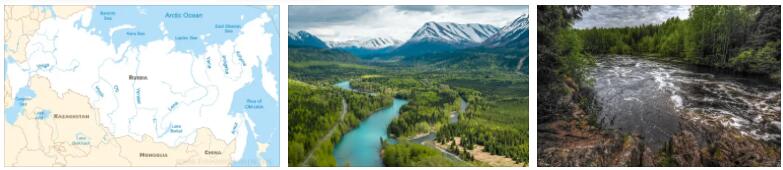
The essential characteristics of that network are: the radial arrangement of the major watercourses, which are at the same time the largest or among the largest in Europe; the ease with which it is possible to pass from the basin of one to that of the other, even outside the central area of the springs – located right in the heart of the town – given the morphological conditions of the latter; the hydrological behavior of these watercourses, all typical low-slope rivers, with a nival regime, with short spring floods and more or less long periods of frost; and the singular development of the valley bottoms which sometimes brings together genetically different trunks, with apparently capricious directions and in contrasting stages of development and which ultimately favors the joining of different and distant regions. Volga, Daugava (Southern or Western Dvina, Zapadnaja D.) and Dnepr feed from an area of very modest importance (the Valdai), within a circle of just 50 km. of radius; and analogous is the case of the sources of the Kama, the Pečora and the Dvina of the North, between which there are also no precise limits. The sources of the Dnieper are at 253 m. on the sea level, those of the Volga at 210, to just 181 those of the Don; and the three rivers must travel a distance of 2138, 3357 and 1808 km respectively before reaching their mouths. Since the watershed between the two opposite hydrographic dominions coincides wholesale, as mentioned, with 60 ° N., the rivers that descend towards S. are the longest (only the Don, among the largest, originates outside from that, on the central shelf); length increased by the fact that these courses of water had to seek an increasingly distant mouth as the marine transgression involving the Black Sea and Caspian basins before the glacial was reduced (thus, for example, the whole stretch of the Volga downstream of Nizhny Novgorod is posterior to the end of this transgression). The same happened, but to a lesser extent, for the currents that flow into the Arctic Ocean; on the other hand, the greater influence that postglacial topography has exerted in the course and shaping of the valleys in central and northern Russia is contrasted, in southern Russia, by a more direct adherence to the tectonic motifs that have conditioned them (think of the analogies of direction which occur in the lower valleys of the Dnieper and Don). Almost everywhere, this has resulted in the alternation, in the same longitudinal profile,porogi, or rapids, of the Dnieper follow, from Dnepropetrovsk to Zaporož′k, for 75 km. course). Rapids and waterfalls frequently interrupt the valley bottoms carved into the area invaded by the Quaternary glaciers (thus, for example, in the same high courses of the Dnieper – upstream of Orsa – and of the Volga), but without compromising the use of these ‘wide network of inland waterways, which holds the record for length in Europe. Thanks to this network, the Caspian is directly connected with the Arctic Sea and the Baltic Sea, while from this it is easy to pass to the Black Sea and from the Black Sea to the Polish rivers. The junction between the various basins is today represented by canals; in the past it was represented by portages at the ends of which some of the major settlements developed.
River communications do not cease to have importance even during the winter frost, which allows you to traffic with sleds. However, navigation is also hampered by the rapid thawing of the snow, which causes sometimes disastrous and often massive floods. The level of the Volga rises more than 10 m. in Nizhny-Novgorod (Gor′kij), 9 in Stalingrad and still almost 4 in Astrakhan, while where the waters are not contained by embankments or terraces, floods occur which isolate entire inhabited areas for several weeks. Fortunately, the regularity and periodicity of the phenomenon greatly reduce its consequences, especially since the settlements have been able to take advantage of the asymmetry of the valley profile – with the left bank low and the right bank raised – characteristic of almost all the major Russian rivers directed in the direction of the meridians. i to 90 for the Loire).
However, where these fluctuations become greater, the deficiency and lack of water reserves represented by the lakes and marshes are evident; and this, even more than the lesser weight exerted by nival feeding, serves to characterize the behavior of the watercourses of southern Russia, with a more sparse network and less regular regime than in the rest of the country. The fact is also related to the Pleistocene glaciation; the limit reached by this in fact marks at the same time, at least roughly, the southern extremity of the area where lakes and marshes appear, albeit less and less numerous and larger as we move away from the circumbaltic region. This is home to some of the largest freshwater bodies of water on the European continent: from Ladoga, however, which is the maximum (18,150 sq km, just under 50 times that of Lake Garda; height 5 m; depth 250 m), it belongs to the USSR only the eastern half, as it is of Pejpus (3583 sq km, height 30 m, depth 17 m.), on the Estonian border. Of those closed in Russian territory, the largest is the Onega (9890 sq km, height 35 m, depth 173 m); followed by Segozero (1246 sq km, height 108 m, depth 99 m), Vygozero (929 sq km) and Il′men ′, the latter among the shallowest (just 4.5 m., in medium) and of very variable amplitude from one season to other (770-2230 sq. km.). Karelia is very rich in lakes (all of glacial origin), like Finland of which it represents the natural continuation, but even further south, in White Russia, there are districts (Vitebsk) in which about 1 / 4 of the total area is represented by lakes. On the other hand, southern Russia is completely devoid of it, when one disregards the coastal formations on the Black Sea, the so-called liman(or brackish lagoons due to the submersion of the river mouths of the currents that end in the Black Sea, and sometimes completely separated from the sea) and by the salt lakes of the Kyrgyz steppe, such as El′ton and Baskunčak, whose level is lower than that of the nearby Caspian. Although subject to more or less long periods of frost (up to more than 5 months on the L. Onega), the major Russian lakes are important for navigation, especially the Ladoga to which they flow, as well as those of the Onega (through the Svir ′), the waters of Lake Saimaa (Finland) and the Il′men ′ (by means of the Volkhov). It is therefore not surprising that the emissary of this large collector, the Neva, although short of course (65 km.), Represents one of the most important in Europe. As for the Volga, the anthropogeographical value of the Neva is however greatly diminished by the fact that it flows into a closed sea; moreover, its navigability is hampered not only by a long period of ice (around four months on average per year), by the rapids that interrupt its course and by the regurgitations that often cause strong westerly winds.
Large expanses are occupied, in central and northern Russia, by swamps and peat bogs, leftovers of endangered or already extinct lake systems, due to the development of the vegetation from which they were invaded; the widest and most continuous area is that which corresponds to the upper basin of the Dnieper, or rather, to the triangular strip, closed between Pripyat ′ and Desna, which drains to the great river, the so-called Polessia, between White Russia and Poland. In addition to their anthropogeographic reflections, these areas occupy a place entirely in themselves as water reserves, like lakes, although the progressive reduction that took place after 1873 has planted crops and forests at the expense of liquid surfaces.
Rivers and lakes represent a much more conspicuous element in Russia in the natural and human landscape than in the Western European world. In addition to being decisive for settlements and communications, therefore for the economic and political development of the various sectors, their function is also notable for the activities that they allowed and continue to feed, and first of all for fishing, almost everywhere abundant. and certainly richer and more profitable, in a country like Russia, than sea fishing itself. This explains the large part that is made to inland waters in poetry, art, folklore, and even the religion of the Russian people.
On the other hand, the scarce importance exercised by activities connected with the sea (leaving aside, of course, the Caspian, actually more lake than sea) cannot be surprising. Although the tendency towards the free ocean represented one of the fundamental reasons of Russian politics, only in a relatively recent period, and essentially beyond its European borders, did the country begin the movement that was to lead it to escape from its long continental isolation phase. The straits through which the Black Sea communicates with the Mediterranean have long been in the hands of the Turks, and as for the Baltic, even before the consequences of the World War narrowed the Russian portion to the thin strip that the USSR keeps at the bottom of the Gulf of Finland, the seafaring activity there was always a monopoly of non-Russian people.
The coasts of the northern Ocean, when one leaves aside the short Murmian coast, are closed for too long by the ice, which block the mouths of the great Siberian rivers for long months. And too far from the European sector, which is still the heart of Russian life, are the shores of the Pacific, while the attempted effort to reach those of the Persian Gulf has been unsuccessful. Characteristics, you can clearly see, far from favorable to the development of a luxuriant seafaring life.