The Norman navigators who, at the dawn of the century. XI, from Norway and Greenland they certainly reached some strips of North America, they probably descended towards the south so as to see the coasts of today’s Maine, nor is it excluded that they went as far as C. Cod; in this case they were the first Europeans to set foot in the territory of today’s United States; but no echo of their discoveries reached Europe. Of no other voyage we have any certain knowledge until 1498, when Giovanni Caboto, in his second navigation, accompanied by his son Sebastiano, went along the Atlantic coasts of the new lands he touched the previous year, perhaps up to the latitude of New York. The trips of the Cortereal brothers do not seem, for what little is known, to have touched the coasts of the current United States, and other discoveries of the following years are uncertain. On the other hand, it is certain that in 1513 Juan Ponce de León, moved from Haiti, recognized the eastern coast of the Florida peninsula (of which, however, there was perhaps vague news a few years earlier); and sure is the discovery that Alfonso Alvárez Pineda, sailing in 1518-19 between the Yucatán and Florida in search of a passage to the west, made the northern coasts of the Gulf of Mexico and the mouths of the Mississippi which he called Rio dello Spirito Santo. But it belongs to the Florentine Giovanni da Verrazzano the merit of having first sailed in 1524 all, or almost all, of the Atlantic coast from 34 ° lat. N. up to C. Breton; in the years immediately following the Portuguese Lucas Vázquez de Ayllón and Estevão Gomes (1525-26) made accurate surveys of these coasts,
In the following years some of the many expeditions sent on the initiative of Hernán Cortés opened the way to the western coasts, which in 1542 had gone up as far as C. Mendocino; further north did Francis Drake arrive only in 1578, in his daring journey, who reached C. Bianco (43 ° N.), the extreme limit of certain knowledge up to the century. XVIII.
In 1528 an expedition led by Pánfilo Narváez and headed for Florida was shipwrecked on the coast of Texas; some survivors, led by Alvaro Núñez Cabeza de Vaca, after wandering for six years through Texas, Coahuila, Chihuahua and Sonora, reached the northernmost of the Spanish places in Mexico, Culiacán, on the Pacific. In 1539 Hernando de Soto departed from Tampa Bay, first penetrated the foothills of present-day Carolina, crossed the Appalachians, reached the Mississippi roughly where Memphis now stands, and, crossing it, entered the Arkansas plains as far as the site of present-day Oklahoma, then went back following the Arkansas River to the confluence with the Mississippi where he met his death. His followers, under the guidance of Luís de Moscoso, after much wandering, canyon, he visited the Pueblos del Río Grande and in 1541 passed the planes of Cibola without finding any trace of the vaunted city of that name. This first great period of exploration ends around the middle of the century. XVI.
However, not many years pass, and the English settle on the east coast of the present United States: after the first unsuccessful attempts of W. Raleigh on Roanoke Island (1584 and 1587), Jamestown was founded, on the estuary of the James River by the Company of Merchants of London (1607), then the establishment of the colonies of New England, following John Smith’s important reconnaissance voyage along the coast, from Penobscot Bay to C. Cod (1616), plus later than other colonies. The Dutch also came with the founding of New Amsterdam on Manhattan Island (1614), and the Swedes with the foundation of a farm on Delaware (1638). But all these settlements, as well as those of the Quakers west of Delaware itself, were confined to the narrow coastal strip, and therefore the exploration of the hinterland made little progress: the mountainous region of the Appalachians was still at the end of the century. XVII entirely unknown and firmly held by the Indians who inexorably rejected the European colonists. It was not until 1716 that Virginia’s governor, Spotswood, crossed the Blue Mountains and discovered the great Shenandoah Valley; since then begins that movement for which the so-called backwoodsmen, a sort of advanced posts, gradually acquire new ground for colonization, both through guerilla operations against the Indians and through peaceful negotiations. There is also the work of religious refugees and missionaries: Presbyterians who fled from Ireland, Herrnhüter Germans, Moravian brothers, etc. The missionaries Chr. Post, David Zeisinger and Johann Hackewalder are credited with the discovery of the source region of Delaware and Susquehanna; others penetrated inland, moving from Charleston, from Savannah founded in 1733, and from Augusta (1739); by the middle of the century the Appalachians were outdated, at least in the whole northern section. In 1748 the Ohio Company was founded in Virginia, which had as its purpose the colonization of the upper basin of this river: from 1767 to ’75 Michele Steiner and Abraham Heit went as far as the Cumberland River and lower Ohio, in 1778 and in the following years Daniel Boone, after founding Boonesborough in Kentucky, penetrated as far as Missouri. In the meantime, the French had made more extensive explorations in the Mississippi basin, that had entered it from the north, that is, from Canada. In 1673 the trader Joliet and the Jesuit Marquette reached the Mississippi from Lake Michigan and sailed it up to about 33 ° lat.; in 1680 Hennepin published the first description of the great river, called the Colbert river, whose relevance to the Gulf of Mexico basin was now ascertained. In 1682 Robert Cavelier de la Salle, after some preliminary reconnaissance, was able, together with the Italian Enrico Tonti, to descend the river as far as the mouth, and he decided to secure possession of the region, which he called Luisiana, by means of a series of forts; killed in 1687 by the Natchez Indians, he found several followers, especially Lemoine de Bienneville, the founder of New Orleans (1718). The interior was traversed by daring traders (coureurs de bois) and as missionaries: thus the Jesuit Charlevoix went west from the upper Mississippi (1720-47), without yet reaching the great western chains, of which a vague news had however already been brought from Lahontan (1688-89). Only Niverville in 1751 in upper Saskatchewan and La Verendrye in 1755 in the Bighorn Mountains actually reached the foot of the Rocky Mountains.
The activity of the French naturally ceases with the loss of their colonial rule in 1763.
The knowledge of the regions aimed at the Pacific made notable progress especially through the work of Jesuit missionaries, radiating from California towards the interior. Among them the father Eusebio Chini, from Trentino, explorer of the region between Colorado and the Rocky Mountains (1698-1701) has a place of honor; with him we remember Salvatierra, Sedelmayer, who recognized a good stretch of Colorado (1744), Escalante, which reached the Great Salt Lake (1776), and the Franciscan Junípero Serra. But all these reconnaissance in reality constituted only a series of isolated itineraries. When, at the end of the century XVIII, the new independent body of the United States was born, huge spaces west of the Appalachians were still almost entirely unknown.
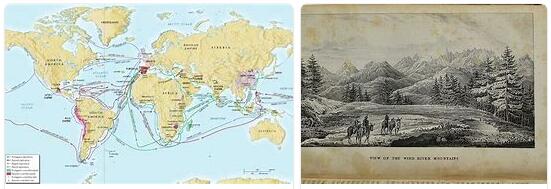
The sec. XIX therefore also opens the era of scientific exploration in the United States. The first period of this period includes the voyages of officers Lewis and Clarke across the Rocky Mountains, from the Missouri basin to the Colorado basin and the Pacific Ocean (1803-05), those of Zebulon M. Pike in the prairie region and in the cordillera of Colorado and New Mexico (1805-07), the great scientific-military expedition led by Stefano W. Long in the Lake Superior region and the upper Mississippi basin (1819-23), the explorations of B.-L. Bonneville in the deserts and mountains of Utah and Nevada (1832-36). The sources of the Mississippi were discovered in 1821 by the Italian Giacomo Costantino Beltrami and almost at the same time also recognized by the Schoolcraft, and in 1843 there was, by the French astronomer Nicollet, the first map of the upper basin of the great river, where shortly afterwards ID Whitney carried out important researches, especially of a geological nature (1847-50). Mainly geological were also Featherstonhaugh’s reconnaissance in upper Missouri and in the Ozark Mountains (1832-35), and those of D. Owen in Indiana (1837-47), while the three great voyages of I. Ch. Fremont through the Northern Cordillera, Oregon and Upper California, those of H. Stansbury in the Great Salt Lake Basin (1849-50), those of Yves and Newberry in the Colorado Basin (1857-59), etc..
The military expeditions against Mexico also served to clarify the knowledge of previously vaguely known regions, especially the semi-desert territories of the south and the mountainous areas of the southwest. The discovery of the California goldfields and later the preparatory work for the first great transcontinental railroad brought new knowledge and data.
For the survey of the coasts the Coast Survey had been created since 1807, which however began its activity only in 1816 and at first very slowly; in 1871 he was joined by the Geodetic Survey, which as its first major work carried out the triangulation along the 39th parallel from the Atlantic to the Pacific; in 1878 the service called Coast and Geodetic Survey was definitively organized. Meanwhile, major geological works were being carried out, such as the survey of the territories along the 49th parallel under the direction of Clarence King (1867-69), the topographical-geological one of the 100th meridian directed by GM Wheeler (1870-78), and finally the great geological-geographical survey of the Rocky Mountains by JW Powell. These great works gave the impetus to the formation of the US Geological Survey (1879), who since 1882 has been carrying out surveys and topographic and geological maps of the Union at the same time and has by now an uninterrupted work of over half a century to his credit; eminent scientists such as GK Gilbert, JC Russel, Cl. Dutton, WH Holmes, D. Whitney, etc.
The United States also has a perfectly organized meteorological service (Wheather Bureau), a Bureau of soils, created in 1901, which looks after the publication of soil and agrological maps, and a Bureau of Ethnology founded in 1879 for the study of ethnography and archeology of the Indian lineages and today aggregated to the famous Smithsonian Institution. The latter body, founded in 1846, carries out a multiple and fruitful activity in promoting studies of all kinds concerning the Union.
In the more strictly geographic field, and at the forefront in that of terrestrial morphology, the work of WM Davis (v.), Who was a true leader, has exerted great influence in the current century, has opened new directions of research and he has also been extensively involved in the creation of university chairs and study centers in geography. The United States today has one of the most famous geographic societies in the world; geographers are affiliated with the active Association of American geographers.
Cards. – The official topographic map of the United States is, as mentioned, published by the US Geological Survey and for the more densely populated and economically important territories it is at the scale of 1: 62.500, in sheets spanning 15 ‘in lat. for 15 ′ in long .; for the rest of the country at 1: 125,000 in sheets of 30 ‘by 30’; the scale of 250,000 (in sheets of one degree per side) originally adopted, has been abandoned. The whole work should be finished in 1941, but it is still very far from completion; moreover, many of the published sheets are based on very summary surveys; only half of the territory today has maps that meet current needs, the seala of 1: 62.500 is applied to a large area of the NE. and in isolation to other areas, usually surrounding large centers. Phototopographic procedures from the plane have been widely used for some years. The same office publishes the one millionth international map of the world for the part concerning the United States (197 sheets) and the United States Geological Atlas in folio issues (about 300 issued out of a total of about 3000), which contain, over the topographic and geological map, a tectonic map, a hydrological map and an illustrative text.
There are many special atlases, including the ‘ Atlas of American Agriculture, the Statistical Atlas of the U. S. A. and the ‘ Historical Atlas of the U. S. A.
As already mentioned, the USA Geodetic and Coast Survey awaits the survey of coasts and seas, which also carries out the fundamental geodetic operations.