Airports
San Francisco is served by 3 airports: San Francisco International Airport, San Jose International Airport and Metropolitan Oakland International Airport.
San Francisco International Airport is about 12 miles / 20 km south of San Bruno on US 101 (Bayshore Freeway) and is served by around 50 airlines and numerous private carriers. http://www.flysfo.com/
Downtown San Francisco can be reached via the North Terminal exit on US 101 heading north. At the US 101 / I-80 intersection, choose I-80 and then take the 4th Street exit. Follow 4th Street past Moscone Center to Market Street, the hotels on Union Square and the Financial District are only a few blocks north and east. The SFO Airporter connects the airport with the hotels in the city center approximately every 15 minutes from 4.50 a.m. to midnight. The price for a trip of about 30 minutes is around $ 11 (as of 2001). Mini-vans offer a shuttle service from the red-and-white-striped zones on pedestrian islands on the airport’s upper level) to the individual hotels at a price of $ 11-20 per person and trip (as of 2001), such as Supershuttle San Francisco, Tel. 800-258-3826, Door-to-Door Airport Express, Tel. 415-775-5121. Taxis to the Civic Center cost around $ 30-35, limousines $ 35-60 (as of 2001).
San Jose International Airport is located 3 miles northwest of downtown San Jose near US 101. From the terminals, follow signs for US 101 and travel north past Palo Alto and San Mateo to downtown San Francisco. http://www.sjc.org
Metropolitan Oakland International Airport on I-880, about 10 miles south of downtown Oakland, should be the destination for those traveling to the east of San Francisco Bay. To get to downtown San Francisco, head east on Airport Drive to Downtown Oakland and take the exit onto I-880 (Nimitz Freeway). Follow I-880 in a northerly direction until you bypass I-980 (detour), which connects you to I-80. Take I-80 west across the San Francisco-Oakland Bay Bridge ($ 2 fee), then exit 5th Street north to Market Street and Union Square / Financial District.
- Allcitycodes: Lists of all area codes of Oklahoma. Also includes state overview and counties by area code in Oklahoma.
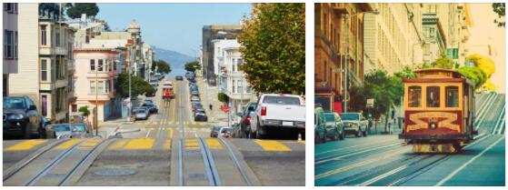
Means of transport
Cable cars: One of the world-famous landmarks of San Francisco are the cable cars and a ride with them standing on the step, the wind in your hair is a must for tourists. There are three lines, two of which start at the corner of Powell and Market Street, where the Visitor Information Center is also located: the Powell-Hyde route and the Powell-Mason route in a north-south direction (Nob Hill; Fischerman’s Wharf). The third line, the California line, runs along California St. in an east-west direction through the Financial District, Chinatown and Nob Hill to Van-Ness-Ave. The stops are marked along the route and you can get on; it is customary to join the queue without grumbling. Waiting times of 45 to 60 minutes are not uncommon in the main season. The route network covers 17 kilometers and carries over 12 million passengers annually. The carriages are driven by a steel rope that is constantly in motion in a rail shaft under the road surface. This drive system has existed since 1873, invented by the English immigrant Andrew Hallidie. Previously, horse-drawn carts had to climb the steep hills of the city. Tip: If the departure station is overcrowded, it can be worthwhile to walk one or two stations and then get on. On departure, the car is never completely filled. The Cable Car Museum, Washington / Mason St., Tel. 474-1887, daily 10 a.m. – 6 p.m. (in winter 5 p.m.), free admission deals with the history of cable cars. In addition to old wagons, the technology of the means of transport is also impressively explained, cf. http://www.sfmta.com/cms/mfares/fareinfo.htm#cable
Buses / Trolley buses: The traffic network of the San Francisco Municipal Railway, Muni for short (also operates the cable cars), is very good and tight. There are numerous line connections at short intervals of around 5 to 20 minutes, which are marked with a number and a name of the terminus (e.g. 5-Fulton, 42-Downtown Loop; displayed on the front and side of the bus). A traffic plan is available at the Visitor Information Center and in numerous shops (Muni map; $ 2.95 – as of June 2002).
Historic road vehicles (Historic Streetcars / Trams): Since 1995, vehicles from all over the world in their original, colorful painting in San Francisco from the center of Market and Castro Street desedimentation Market Street through downtown to Fisherman’s Wharf with the terminus Jones and Beach Street used (Line F-Market).
Metro: The trams on the F-Market, J-Church, K-Ingleside, L-Taraval, M-Ocean View and N-Judah lines run underground in the city center and above ground in the outer districts.
Taxis: Taxis calculate their prices using a taximeter. The first mile costs about $ 2 and each additional mile about $ 1.80 (as of 2001). Taxis are ordered by phone, otherwise they can be found in front of every well-known hotel. A hand signal on the street is usually not successful.
Alcatraz tips
Alcatraz is located in the middle of the San Francisco Bay, 1.5 miles northeast of San Francisco and can only be reached by Red & White Fleet ferries, which depart from Pier 41 of Fisherman’s Wharf. The crossing takes about 20 to 25 minutes. A steep path leads from the pier to the former prison, which can be viewed from the inside, with or without an audio guide. Tickets are available at the counter at Pier 41, which is open Mon – Fri from 9 a.m. to 5 p.m. and Sat, Sun from 8 a.m. to 2 p.m. (Tel. 415-705-5555).